Hydrological Data Recorded in or near the
Suwannee River Watershed: Hydrologica Data
Surface Water Quantity Station
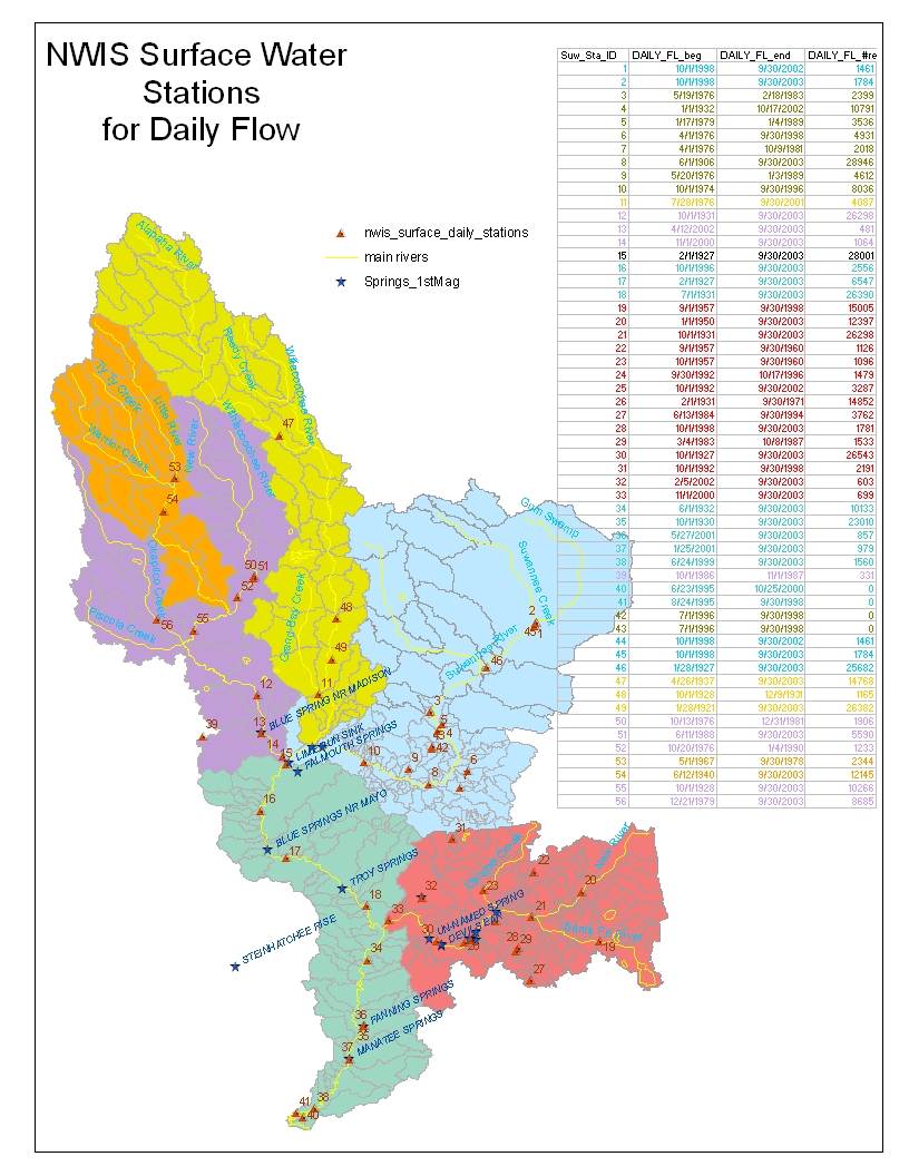
The National Water Information System (NWIS) has numerous river and surface water gaging stations. The records of each are not uniform, however, and the map at right provides an indication of the period of record. All of the stations shown are available at the USGS Surface -Water Data for the Nation. All of the archival data (daily and monthly summaries) for the Santa Fe River basin have been downloaded. The digital watershed geodatabase will provide a weblink for each station directly to the period of record data.
 Real-time surface water levels are also available from the SRWMD. These stations are primarily in Florida (2 in Georgia) and on the Suwannee and Santa Fe River mainstems.
Ground Water Stations
- USGS National Water Information System (NWIS) stores and retrieves ground water level and quality data
- Maps of Ground water stations
 The WARN network from the Suwannee River Water Management District reads and archives ground water levels throughout the Florida portion of the Suwannee Basin.
GIS coverages and data from the FGS research study on aquifer protection, the Florida Aquifer Vulnerability Assessment (FAVA) is available here.
GIS coverages and data from the FGS research study on aquifer protection, the Florida Aquifer Vulnerability Assessment (FAVA) is available here.
Water Quality Information
EPA STORET (STOrage and RETrieval) System for Water Quality
There are 3213 stations in the Suwannee region (many are in the Econfina, Fenholloway and Aucilla basins that are part of the Suwannee River Water Management District). The data are searchable by station, HUC code, and lat/long box. We have obtained the geographic data for:
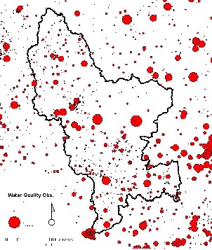 The National Water Information System (NWIS) - has several water quality stations in the basin. The records of each are not uniform, however, and the map at right provides an indication of the number of record. All of the stations shown are available at: USGS Surface-Water Data for the Nation. In general, the available data are for short periods, and for only a small number of parameters (e.g. alkalinity, temperature, DO). The availability of long term water quality indicators (e.g. nutrients, DOC) is limited.
- Maps of Water Quality Stations
- Spreadsheet (107KB xls) of Water Quality Stations with links to NWIS system
FL Springs Initiative - In Florida, the declining condition of springs was recognized in 1999 by the Secretary of the Florida Department of Environmental Protection who directed the formation of a multi-agency Florida Springs Task Force to recommend strategies for the protection and restoration of Florida’s springs. The task force produced a report identifying current problems in Florida’s spring systems as well as a series of recommended “Action Steps.” Early in 2001, the Florida Springs Task Force II was formed to guide implementation of the “Action Steps” in the report. During the same year, the Florida Legislature, with the support of the Governor and FDEP’s Secretary, allocated approximately $2.5 million to fund the Florida Springs Initiative, which began the process of protecting and restoring Florida’s springs. Springs Initiative funding was continued in 2002, 2003 and 2004, with a total of approximately $9.9 million, appropriated to continue these efforts. In 2002-2003, approximately 7.5 million have been spent in three broad areas: research and monitoring; landowner assistance; and educational outreach. Continuous funding has enabled the state to pursue protection efforts that focus on identifying in greater detail ground water spring basins and associated land uses and threats, continued research and monitoring, and education
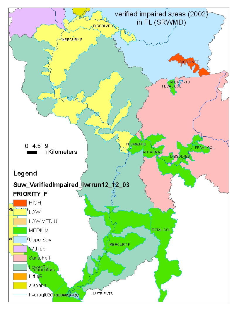
Impaired subwatersheds - From FL DEP:
Georgia Water Resource Information
The USGS Water Resources of Georgia page has data on streamflow, groundwater levels, water quality and rainfall inputs. They also summarize the Georgia Water Information Network (GWIN) which reports water resource data on a county-by-county basis, including some real time stations.
Florida Water Resource Information
The Suwannee River Water Management District provides several forms of water monitoring within the Florida portion of the basin. Among these are surface water gaging stations, ground water monitoring stations (seasonal, monthly and real-time) and water quality stations.
 The USGS Water Resources of Florida page has data on streamflow, groundwater levels, water quality and rainfall inputs.
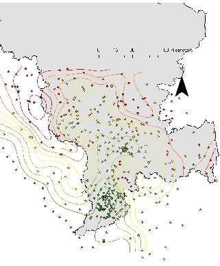 The Suwannee River Water Management District used over 200 ground water levels to produce an interpolated ground water level contour map. This map, a static view of the maximum ground water levels in 2002. shows that the contributing basin with respect to ground water flows is somewhat larger than the basin delineated using surface water flow (as evidenced by the location of the groundwater ridges to the west of the western basin boundary).
Soil and Geologic Base Layers
 Coarse soil layer information is available through the SSURGO program (Soil Survey Geographic database) through the NRCS. We have obtained the layers for Florida and Georgia; while the boundary conditions are well matched, the attribute data for the files are not identical, making merging the maps problematic. A uniform coverage of soil layers is under development for the Suwannee Basin. based on mediation between the Florida and Georgia map unit ID systems.
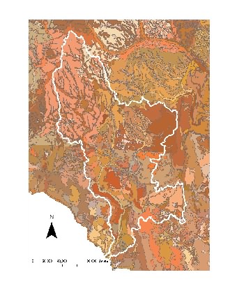
Geological information for the Suwannee River Basin is particularly problematic because of “state fault lines”. Data are compiled from the Florida Geological Survey and the Georgia Geological Survey, but they do not match up well (in attribute definitions or in spatial topology).
Ancillary Base Layers
(Elevation, Population, Land Use, Ecoregions)
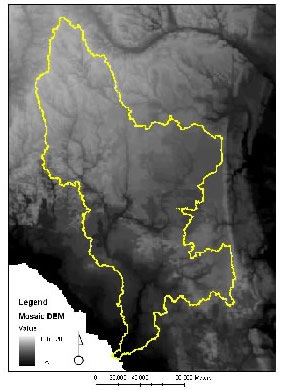 The National Elevation Dataset is a new elevation product assembled by the U.S. Geological Survey (USGS). It was designed to provide national elevation data in a seamless form with a consistent datum, elevation unit, and projection. Data corrections were made in the assembly process to minimize artifacts, permit edge matching, and fill sliver areas of missing data.
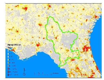 The LandScan data comprise a worldwide population database compiled on a 30" X 30" latitude/longitude grid. Census counts (at sub-national level) were apportioned to each grid cell based on likelihood coefficients, which are based on proximity to roads, slope, land cover, nighttime lights, and other information. LandScan has been developed as part of the Oak Ridge National Laboratory (ORNL) Global Population Project for estimating ambient populations at risk. The LandScan files are available via the internet in ESRI grid format by continent and for the world, and in ESRI raster binary format for the world.
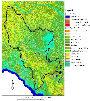 The National Land Cover Database (NLCD) documents land cover patterns across the entire United States in 30x30 m pixels. The classification is inferred from satellite imagery (primarily Landsat) and is reported in 21 land cover categories. The product is delivered with a state by state accuracy assessment. Currently available data in the Suwannee Basin are for 1992, but the 2002 update is scheduled to cover the entire SE
Ecoregionalization is an 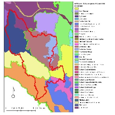 effort to delineate regions of the country (at various resolutions) that are biologically, climatalogically, physiographically, edaphically and hydrologically similar. The Level III ecoregionalization is coarse; the Suwannee Basin covers two Level III ecoregions (Southern Coastal Plain and Southeastern Plains). Level IV ecoregionalization is more specific, with 8 classes in the Suwannee basin.
Future Projects
Data sets that we have obtained that are not yet posted here:
- SRWMD Groundwater monitoring stations
Hydrographic Data
 Hydrologic Unit Code (HUC) level 8 basin delineation. These data, derived from topographic maps delineate the boundary of the large sub-basins in the Suwannee watershed (Santa Fe, Withlacoochee, Okefenokee, Little, Alapaha, Upper and Lower Suwannee). Finer resolution basin delineation maps are also available.
The National Hydrography Data (NHD) is a comprehensive set of digital spatial data that contains information about surface water features such as lakes, ponds, streams, rivers, springs and wells. Within the NHD, surface water features are combined to form "reaches," which provide the framework for linking water-related data to the NHD surface water drainage network. These linkages enable the analysis and display of these water-related data in upstream and downstream order.
These data come at various resolution, all of which we have obtained. The finest resolution includes all water bodies, including wetland boundaries. However, it has serious flaws across state boundaries. The medium scale hydrography data set (shown at right) includes all major stream corridors.
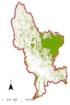 The National Wetlands Inventory (NWI) is a classified thematic map of wetlands throughout the US, provided by the US Fish and Wildlife Service. The maps produce and provide information on the characteristics, extent, and status of the Nation's wetlands and deepwater habitats and other wildlife habitats.
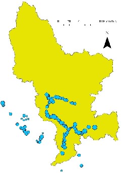 Springs in the Suwannee Basin. The map shows the springs in the Suwannee River Water Management District, scaled according to the spring magnitude. Some of the main springs are monitored regularly under the purview of the USGS and SRWMD gaging stations.